One of the most exciting weekends of the year in Central Florida is here! It’s time for the Daytona 500. This will be the 60th running of the “Great American Race.” Sometimes that seems like a long time, other times it seems like we’ve had this race for all time. No matter how it strikes you its officially the 60th. Here’s to it being a classic.

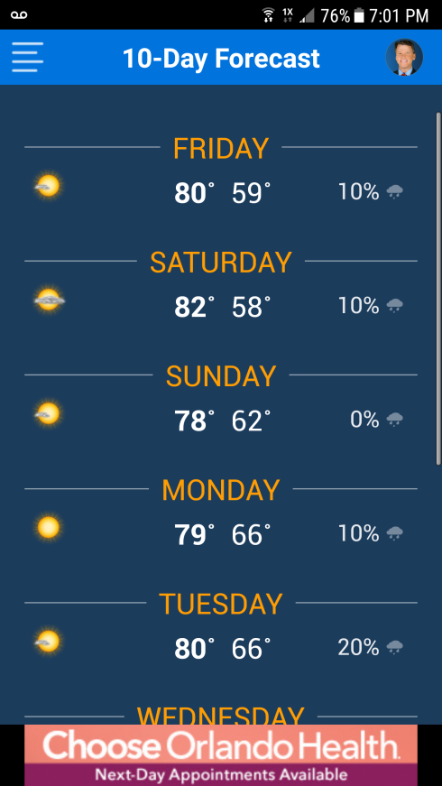
All week long we have been dealing with above normal temps. Today was no exception. In Orlando the high made it up to 85. We missed the record high by 2 degrees. The record on this date is 87 from back in 2001. In Daytona Beach the high today was 80. The normal for Daytona Beach this time of year is 71.

The overnight lows this week have been just cool enough to produce patchy fog. Tonight the low in Orlando is set to go to the mid 60s. That will be cool enough for patchy fog to make a return. It looks to me like the fog will be worse north of the I-4 corridor in Orlando. That would mean Daytona Beach will wake up to fog both Saturday and Sunday morning. But that fog will burn off before 9 or 10 and the race day forecast is good to go. Look for the high on Sunday in Daytona to be 78.

daytonforecast


With the weekend looking great I just want to serve up a reminder that all of your favs from News 6 will be spending time at the Sea Food Festival in Brevard county.  Julie and Troy Bridges will be there from 1 until 4 p.m. Saturday.  Matt Austin, Ginger Gadsden, Lisa Bell, and I will all be there from 4 until 7 p.m. Saturday afternoon.  Come see us…the weather is going to be near perfection.

Oh, and for the record, I’m pulling for Danica Patrick to win the 500. I mean come now, how cool would that be for her to win it all on her last try? As the father of a house full of girls I would love nothing better than to have a woman win. So good luck Danica. God Speed!

See you all on News 6.

Bye now.


By now you have heard, probably MANY more times than you wanted to, that we are about to see a “Coast-To-Coast” Solar eclipse.  It is all over the news, featured on the cover of magazines at the store check out, and has too many post on Facebook to count.

This map from NASA shows the track the shadow of the moon will place across the U.S.A. on Monday August 21st. The shadow of the moon will start to block out the sun on the west coast in Oregon.The reason this eclipse is SO special is because it will go all the way from “sea to shining sea” as the old song says.

This eclipse is going to special to me because I plan on being with my mother in the path of totality. A little backstory here: I was born and raised in Middle Tennessee. My mom still lives in the house I grew up in. When I found out that the eclipse was going to go RIGHT over my childhood home I felt it was important to be there. Ergo, I have taken time off from work, made plans to travel, and will be in Greenbrier, Tennessee with my mom and my sister to experience this astronomical event.

I get that most of you in Central Florida can’t make that journey with me. That leads to the question:  What will happen in Florida? Okay, I don’t want you to think that its going to get super dark here in the Orlando area.  Below is a graphic that shows what the eclipse will look like in SW Orange county. The farther you are to the north in Florida the closer to the band of totality you will be.  As I am writing this, on Wednesday afternoon, the forecast calls for Partly Cloudy conditions at 2:51 P.M. on Monday.  With 82.5% of the Sun blocked you will still see lots of sunshine. It absolutely will NOT safe to look at the sun without special eclipse glasses. It will NOT get dark outside in Orlando. Keep that in mind as you make your plans.
orlando eclipse look

Ground zero for this eclipse is Hopkinsville, Kentucky. I used to live in Hopkinsville in the 80s. There was a TV station there called TV43. It was an LPTV station. LP stood for Low Power, and LOW PAY!   But I love the city of Hopkinsville for giving me a start in the business that I love. I won’t make it to “Hoptown” for this celebration. But the people there are going all out.  Members of the “Digital Team” here at WKMG News 6 are going through there for extended coverage on Friday. I am so happy for the folks in Hopkinsville.  Below is what the eclipse will look like there.

hoptown look

My biggest fear is that the weather will not play along on Monday.  As of right now, this is the forecast for viewing. At my moms house in Tennessee the sky looks like viewing will be fair. That is exciting! Here in Florida it appears “Good”.

So the bottom line is we should have a good view of the event from Florida on Monday, but we will NOT be in the area of totality. I don’t think the weather is going to let you down, Please make sure you understand that it wont be a total eclipse here so that you don’t come away disappointed by the event.

eclipse weather at peak

Make sure you are careful when viewing.

Follow these tips:

vieweing tips

If you miss this eclipse check out the map below to see when your next chance comes along.


Okay, I have to run now. I will be back on here with more eclipse stuff. Weather action, and all that jazz as the big event approaches.

See you here and on News 6!


I think I’m in love with the Ace Cafe.

If you know me you know I love history, I love Orlando, and I LOVE motorcycles. This place is gonna have all 3 in one location.

Today I was lucky enough to get to go on the “Hard Hat Tour” of the facility.

hardhatsace

I didn’t count the number of people who were there…but it seemed like about 30? I took this picture before it all got to going. We are in the lower part of the Ace Cafe. It is set for a late April soft opening. They say it should be ready for a hard open celebration about a month later.

If you have been around the motorcycle scene in central Florida anytime in the last few years you have probably seen some of  promotional material for the Ace Cafe. I first heard of them when I was at the American International Motorcycle Expo. That was about 3 years ago. So it’s been a long time coming. It took the developers so long to get the place to market because the  needs and problems associated with renovating a historic building.

acelobby

The Ace Cafe is being created in the old Harry P. Leu building on Livingston Ave.


enteracecafe

In a city that is NOT always known for taking care of its history it makes my heart warm to see these people showing love for this place.  The name Harry P. Leu is still left on the sidewalk in tile in front of the Livingston Avenue entrance.

tiles

One of the areas inside on the second floor is the old office of Harry P. Leu himself.  It will be restored to a “Mad Men” style of office.  There are other touches from the original use of the building. There is even an old safe that hasn’t been opened yet. The Ace Cafe folks say they are looking to get a safe cracker to work on it and hope to do something like a “Al Capone’s Vault” opening of the safe.

safe

Okay… pics of the bar at the cafe are impressive. This one will be an outside bar with an awning for protection from the sun. I was there mid-morning and it felt great. I would have to believe the spot will do well.

baracecafe

The roots of the Ace Cafe go all the way back to 1938 in London. It is a HUGE part of biker lore. For a history of the cafe click the link below:

History Of The Ace Cafe

The Ace Cafe in Orlando will have a clock tower. This is what it looks like right now.

clocktowerace

This helmet was on display today. The Ace Cafe has a deal with Bell Helmet. I liked it..but it was not for sale. Not today anyway.

helmentacecafe

And here is the Ace Cafe Model motorcycle from Triumph.  This one in Orlando is the second to roll off the line. I LOVE this bike. Lucky for me that, just like the helmet, it was NOT for sale. I can’t really be buying every thing I like in this place. I have kids to put through college.

cycle

I am excited about the prospect of the Ace Cafe opening in late April. I believe its going to be a really cool addition to downtown Orlando. I think it will become a target destination for all bikers. I can see it becoming a big part of Biketoberfest, and Bike Week, as soon as it opens.

Weather: GREAT weather if you like it warm. Today we hit a high of 87 at OIA. That is 7 degrees above normal. Tonight we have no rain in the forecast, and a low of 63. Tomorrow looks hot again with a high of 87. So far in 2017 we have yet to hit a high of 90. That could happen as early as Thursday.

Ride safe.


I’m sitting here in Orlando watching my beloved Dolphins struggle against the Patriots. I am so happy to be able to watch them on this last Sunday of the regular season. I am not happy that they are getting thumped. Such is life. It appears the Dolphins will still not be champions in 2017.

I’m just hopping on here for a quick update. Today is a 10 on the Sorrells Scale.

sorrellsscale10

It really is a perfect afternoon. The high today will be about 81 in Orlando. Tonight the fog, that was here this morning, will return late.

A chance of rain returns on Tuesday.

Speaking of returning, my vacation is OVER. It’s always a bummer to see the vacation end… but I am blessed to have a gig I love. Totally blessed. I will be back on the newscast tomorrow starting at 4 P.M. Please tune in.

The stats on 2016 are in. Can you guess how hot last year was? The final numbers for 2016 in Orlando places it as the 4th warmest year on record. I knew it was a hot one, I didn’t know it was gonna be in the top 5. Here are the stats released from the NWS in Melbourne this morning.

Check out the numbers.  I’m going back to the game.

See you soon.

Temperatures...

Both December and 2016 were in the top 5 warmest on record for the
majority of primary climate sites across east central Florida. Here
are the average temperature rankings for both periods at Daytona
Beach, Orlando, Melbourne and Vero Beach...

December 2016:

Site:     Avg Temp/Departure(F):    Rank:
Daytona       65.7 (+5.2)        7th Warmest* (Records Began 1923)
Orlando       68.8 (+6.2)        4th Warmest  (Records Began 1892)
Melbourne     69.5 (+6.5)        4th Warmest  (Records Began 1937)
Vero Beach    70.8 (+6.2)        3rd Warmest  (Records Began 1942)

*Ties 2007

Year 2016:

Site:     Avg Temp/Departure(F):    Rank:
Daytona       72.7 (+1.8)        5th Warmest
Orlando       74.2 (+1.4)        4th Warmest
Melbourne     74.4 (+2.0)        3rd Warmest
Vero Beach    74.5 (+1.4)        5th Warmest

Precipitation...

Well below normal precipitation continued into December across most
of the region, with this past month ranking as Melbourne`s 4th
driest December. However, year end rainfall totals were generally
near to above normal for many locations in east central Florida,
especially at Vero Beach where 2016 ranked as their 10th wettest
year.

December 2016:

Site:      Total Precip/Departure:      Rank(If in Top 10):
Daytona          0.70" (-1.93")
Orlando          2.52" (-0.06")
Melbourne        0.32" (-2.25")             4th Driest
Vero Beach       2.14" (-0.05")

*Ties 2007

Year 2016:

Site:      Total Precip/Departure:      Rank(If in Top 10):
Daytona         44.64"  (-4.98")
Orlando         54.30"  (+3.57")
Melbourne       59.64"  (+7.64")
Vero Beach      65.30" (+13.43")            10th Wettest

At 11 A.M. it was 77 degrees at my house. It feels great. Really, it does. But let’s be honest, it’s not what I would have picked for Christmas Day. Strange thing is I was writing the same words this time last year. Do you remember last Christmas? If you live in the Orlando area it was the HOTTEST Christmas on record. We pushed right through the mid 80s to a high of 86 last Christmas Day. My graphic from last year looked like this:

hot christmas


Before last year, as you can see on this graphic, the hottest December 25th ever in Orlando was in 1924. That record stood for a long time. I didn’t mind it being a record year last December… but this year I was hoping for a return to normal. Looking at this graphic makes me long for the Christmas of 2014 when the high only hit 65. I would SO love that kind of day.

With all of our gifts exchanged, holiday shows watched, and only one more holiday meal on the menu, I’m thinking I just might crank the temperature down on the A/C and see if I  can convince my wife to make us all our favorite hot chocolate!

The next cold front will be here soon. By next Friday the temp will be a little more seasonal.

Merry Christmas to you all. No matter what the temperature.


Welcome to Hurricane Season 2016! We all know that the season started way back there on June 1st, but the action is just now starting. We are already tracking the “F” storm with the remnants of Tropical Storm Fiona. That system is now moving NW through the Atlantic as a Tropical Depression. It looks to not be much of a threat to anyone except shipping lanes.

fiona


Next up we will have a Tropical Storm named Gaston. Gaston will be WAY across the ocean. As I am writing this the models for the system will become Gaston all agree that it will be a pretty big, well defined, hurricane. They also all agree that Gaston will also stay out to sea, be a huge concern for shipping lanes, and remain a “Fish Storm” that never hits land.Check the models below:

Gaston models


The other system is the one that will cause us the most concern. Right now this system is called Invest 99. Its actually closer to us, will be more of the threat, but will end up with the “H” name. So lets be clear, the next named storm is Gaston. It will never be a threat. The next “threat” is from Invest 99/Hermine. For the last 24 hours each model run has moved the potential track of this system to the east. This is the latest set:

Hermine models

Here is a satellite shot of all 3 systems together.

satshotofall3

What is left of T.S. Fiona is there. You can easily spot Invest 90, that will be Gaston, over on the right hand side of the pic. It’s only half way visible in this picture, but you can see how HUGE it is . Right in the middle is Invest 99/Hermine. It’s going to take some time for this one to develop. It’s spinning already but is not well defined. No perfect center, its still very wide. I’m not expecting rapid intensification here. The National Hurricane Center lists the chances like this:

* Formation chance through 48 hours...low...20 percent
* Formation chance through 5 days...medium...50 percent

That’s a good call. It will be something we have to watch closely. It’s 5 days away from having a name… If it really becomes a player in our forecast it will be on a Friday through Sunday time line. It will be mentioned here on the blog, all over Twitter, Facebook, and will be featured in every weathercast on News 6 at 4, 5,6,7, and 11.

Keep in mind that we just now beginning the start of the meat of the season. The graphic below shows the ramp up in action we look for after August 1st. The actual peak of the season is September 10th.

The next week is just one week of many that we REALLY have to pay attention.

peakofseason

Oh, and for record… today is just flat out HOT. Look for the high at OIA to be 95 with a Heat Index of at least 102. Rain chances are low, low, low, at only 20%. If it does not rain, it gets REALLY hot.


With a  cool weekend ahead you may find it easier to get in the holiday spirit. But heed my words: You should enjoy your hot chocolate quickly. We are about to have the hottest Christmas Day ever in Orlando.

With Christmas a week away there is still some wiggle room –  a record-breaker is not a guarantee. But the models are leaning that way.

“Extended Long Ranger” numbers are calling for highs to climb steadily through next week.  Keep in mind a normal high this time of year is  72 degrees. A normal low for the week of Christmas is 51. Not this year.

The record for the hottest Christmas ever in Orlando is 85 degrees from 1924.  As of right now my prediction for Christmas Day this year is 86! It’s not a smashing of the record, but it will be a record just the same.


hot christmas

Some will blame El Nino. Everyone knows it’s been an El Nino season so far. But actually record heat is not a characteristic of El Nino. El Nino winters in Central Florida tend to be stormy – our tornado threat goes way up – but we generally have near normal temps early followed by below normal temps in February. So, what’s the deal?  Is it “Global Warming”? Well no, probably not. Last year we had a high of 65 on Christmas Day. I really believe it’s just a strange run of heat. The whole fall season has been dominated by a HUGE, persistent ridge of high pressure over the Atlantic Ocean.  While we have just finished up the warmest fall season (Meteorological fall is September, October, and November. By astronomical definitions fall is not over until December 21st) on record, it’s not like we haven’t had December heat waves before.  The Christmas record, from 1924, was a really hot year. Two other December record hot days are from that same year. The hottest December day of all time was a 95 degree reading on December 1 from 1922.

We have also had some of our coldest weather during Decembers past. The coldest temperature ever in Orlando was 18 degrees on December 28, 1894.

The bottom line here is our weekend will be a taste of Florida winter. But enjoy it while you can. Drink the hot chocolate quickly, the hottest Christmas ever is on the way!

Hi there. I am not a happy camper right now. The Dolphins are on WKMG…but they are NOT winning. I wanna take a break and give you an update on the Supermoon.

#1 The whole things starts at 8:11 P.M. That is the moment that the Moon begins to move in the shadow of the Earth. Cool stuff!

#2 Right at 10:47 is when it hits its max. If you can see it then it will be spectacular. Which brings us to then next point.

#3 Have you seen radar? Just click the link below. In a nutshell…”It’s gonna rain.”

http://weather.clickorlando.com/

and even though the rain will come to an end before the eclipse of the “Supermoon” I don’t believe the clouds will break long for us to enjoy the eclipse.. So the Supermoon looks more like it will be a Superbust for us in Central Florida. Bummer.

Supermoon

If only the sky were as clear as it is in this graphic from News 6.

In the meantime there is a Coastal Flood Advisory for Flagler, Volusia, and Brevard counties through tomorrow night.

Here is how the NWS put it in their discussion this afternoon.

 COASTAL FLOODING...HIGH ASTRONOMICAL TIDES DUE TO LUNAR
  CYCLE...AND A BUILDING NORTHEAST SWELL INTO MONDAY WILL CAUSE
  MINOR COASTAL FLOODING FOR TYPICALLY VULNERABLE LOCATIONS ALONG
  THE EAST COAST BEACHES AND SOME AREAS ALONG THE INTRACOASTAL
  WATERS AROUND THE TIMES OF HIGH TIDE INTO MONDAY. WAVE RUNUP TO
  THE BASE OF THE DUNES IS ALSO EXPECTED AT MANY EAST CENTRAL
  FLORIDA BEACHES NEAR THE HIGH TIDE.

* TIMING...THE HIGH TIDE OCCURS SUNDAY EVENING BETWEEN 7 PM AND 9
  PM...MONDAY MORNING BETWEEN 7 AM AND 9 AM AND MONDAY EVENING
  BETWEEN 8 PM AND 930 PM.

* IMPACTS...INUNDATION OF WATER MAY OCCUR IN LOW-LYING AREAS NEAR
  THE EAST COAST BEACHES AROUND THE TIMES OF HIGH TIDE THROUGH
  MONDAY.

Again it's a bummer about the clouds and the eclipse, but the flooding is a lot more troublesome. 
I'm going to go back and watch the Dolphins now. They are still my team no matter what. I will return to the studio tomorrow at 4 P.M. on News 6. 

Hope to see you there.

The SpaceX launch was scrubbed this evening because of the upper level winds not the winds at the surface. The situation should improve for tomorrows window and I would bet the launch happens tomorrow.

Tonight the sky goes Partly Cloudy. The low in Orlando will drop to 45 degrees. Look for our winds to slow down. Wind will still be from the north but only at 10-15 instead of 20 M.P.H.

The big story will be how nice it becomes for the next 48 hours and how COLD it gets after that.

Check out the 7 Day Planning Forecast below:

:twitter (1)

Normal high this time of year is 73, normal low is 52.

If it makes you feel any better the low in the nation today was -11 in Gaylord, Michigan.

In Providence, Rhode Island they have already had more than 43 inches of snow this winter…they usually only get 33.8 inches.

I will see you tonight at 11 on Local 6 News.

Back to Back record weather days. Yesterday it was the heat, today it’s the rain.

As of right now Daytona Beach and Orlando have both set record rainfall for the date.

recordstue

Other totals for the day are impressive. One viewer in Edgewater in Volusia county is reporting more than 7 inches of rain.recordrain

As we go through the night we will have the cold front moving over Central Florida. The front should clear Orlando around daybreak. Most of our showers will end as the front passes, but before it stops we should have 2 to 4 more inches.

That will mean an end to the rain and a beginning for the colder air. The low tonight drops to 57… the high tomorrow will crawl back to 64.

The Forecast for Thanksgiving Thursday will Fantastic if you like it cool. The high will be 67 under a sunny sky.

For Black Friday the weather looks great,..you could not PAY me to go shopping, but if you do hit the stores for deals, the weather will be GREAT. Look for more sunshine on Friday with a high of 66.

Saturday and Sunday both look nice with the highs making it back to the mid 70s and no chance of rain.

Enter your email address to subscribe to this blog and receive notifications of new posts by email.

Join 12K other subscribers